Description
Global Positioning System (GPS) is a technology that can locate positions or navigate the user to a location. GPS uses a constellation of 24 navigational satellites to determine positions on the earth’s surface. Geographic Information System (GIS) is mapping software that can link information about where things are with information about the location, e.g. soil type, vegetation, topography, roads, etc.
GPS units need a signal from at least three satellites for minimal operation. Current handheld units using WAAS are accurate within approximately 10 feet and cost from $150 to $450 depending on options. These units are popular with hikers, hunters, and fishermen. Real-time applications for mobile equipment can cost $10,000 to $40,000 or more depending on accessories.
Application
Combining GPS and GIS can direct tractors, four wheelers, aircraft, or persons on foot to desired field locations. Additionally, these systems can be programmed to direct mechanical operations, e.g. variable-rate sprayers, fertilizers, or seeders, etc. This technology is revolutionizing many agricultural operations.
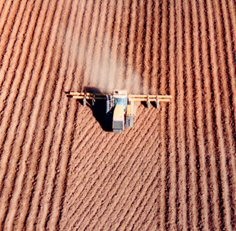
Aircraft units can display maps of fields to be sprayed, guiding each swath, and logging the flight pattern of aircraft. Tractors use GPS to control variable rate applications of agricultural materials, and Real Time Kinematic (RTK) systems are available to accurately steer the tractor. Brush control projects are using GPS to guide tractors or aircraft during applications to protect wildlife habitat, clear selected areas, and provide aesthetically pleasing landscapes.
Images